بئر ماعین
بئر ماعین
بئر ماعین | |
|---|---|
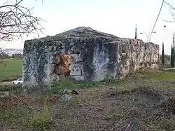 Sitt Mena, one of five sisters, whose maqam is just northeast of the centre of Bir Ma'in | |
| ریشهشناسی: The well of springs | |
پرونده:Historical map series for the area of بئر ماعین (1870s).jpg 1870s map
پرونده:Historical map series for the area of بئر ماعین (1940s).jpg 1940s map
پرونده:Historical map series for the area of بئر ماعین (modern).jpg modern map
پرونده:Historical map series for the area of بئر ماعین (1940s with modern overlay).jpg 1940s with modern overlay map
A series of historical maps of the area around بئر ماعین (click the buttons) | |
  بئر ماعین Location within قیمومت بریتانیا بر فلسطین | |
| مختصات: ۳۱°۵۳′۱۷″ شمالی ۳۵°۰۱′۱۲″ شرقی / ۳۱٫۸۸۸۰۶°شمالی ۳۵٫۰۲۰۰۰°شرقی | |
| Palestine grid | ۱۵۲/۱۴۳ |
| Geopolitical entity | قیمومت بریتانیا بر فلسطین |
| قضاهای قیمومت بریتانیا بر فلسطین | Ramle |
| Date of depopulation | July 15–16, 1948 |
| جمعیت (۱۹۴۵) | |
| • کل | ۵۱۰ |
| Cause(s) of depopulation | Military assault by یهشو forces |
| Current Localities | مودیعین-مکابیم-ریعوت |
بئر ماعین (به لاتین: Bir Ma'in) یک منطقهٔ مسکونی در قیمومت بریتانیا بر فلسطین است که در رمله (شهر) واقع شدهاست.[۱] بئر ماعین ۵۱۰ نفر جمعیت دارد.
جستارهای وابسته
- فهرست شهرهای قیمومت بریتانیا بر فلسطین
منابع
- ↑ مشارکتکنندگان ویکیپدیا. «Bir Ma'in». در دانشنامهٔ ویکیپدیای انگلیسی.
پیوند به بیرون

در ویکیانبار پروندههایی دربارهٔ بئر ماعین موجود است.